At a glance
How much can a pile of rock change a city? Alexander’s mole, a roughly kilometre-long ramp of stone and wrecked ships heaped into the channel, turned Tyre from an island fortress into a peninsula and altered how the city met the sea, its defenses, and its economy. That single engineering act closed a sea lane that had structured Tyrian life for centuries and then set in motion sedimentation that reoriented the harbor for generations.
What happens when a military solution becomes a geological one? Alexander’s engineers built a causeway — a broad band of dumped stone, timber, and the hulls of captured ships — that reached from the mainland to Tyre’s island acropolis. The work read in the flesh: a pale, artificial spit cutting through the blue channel, its surface churned by constant hauling, its edges tumbling with waves and spray. Contemporary accounts describe carts and ropes, men wading chest-deep as they guided stones; the visual would have been of a new land being born in the teeth of the sea.
Physically the mole was not a neat, paved road but a mass of rubble and wreckage large enough to interrupt tidal flow. That interruption mattered. Currents that had kept the channel clear slowed; sediment deposited where water eddied behind the new barrier. Over decades the churned shell and sand gathered into shallows that stitched the island to the mainland. What began as a siege technology became a permanent rearrangement of shorelines and quays.
Think of Tyre before this: an island crown whose harbors framed the city’s warehouses, dye vats, and slipways; a place where ritual and shipping met at the temple quay. The mole rewired that geometry. Approaches that once required small boats now became streets. Harbors filled in unevenly; some basins became marshes, others were extended and reclaimed. The island’s defensive logic — sea as moat — was neutralized by the slow, patient work of deposited stone and silt.
Compare this to other engineered harbors: where planned breakwaters aimed to shelter a port, Alexander’s causeway began as a tactic and ended as an agent of landscape change. The sensory experience shifted as well. Instead of crews crossing a blue gap, people walked firm ground where waves had been. The smell changed: from the briny churn of ships and murex vats to the dust of hauled stone and the sour smell of newly trapped shallows. That transformation altered where merchants moored, where craftsmen set up, and where power physically sat between palace, temple, and quay.
Closer looks
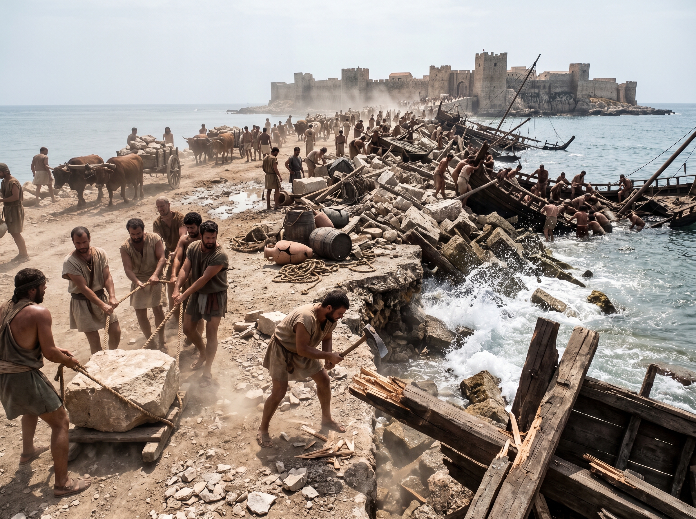
Building the mole: men, stones, and broken hulls
What the mole began as was brute improvisation: men, ropes, and whatever hulls they could tear apart. Workers hauled fist-sized and house-sized stones on sledges and with oxen, chest-deep in water as they jammed wrecked ships into place, sawed through masts and shoved tarred planks into the gap to catch the next load of rubble. The scene smelled of hot pitch, salt, and crushed wood; splinters and rope fibers littered the pale surface where amphorae and broken cargo tumbled in the surf. Contemporary estimates imply a workforce in the low thousands, which helps explain the scale of coordination — squads who cut timbers inland, others who rowed in captured hulls to be scuttled, and teams onshore dragging rock up steep ramps.
Contemporary accounts and modern estimates place the workforce in the thousands, with captured ships deliberately stripped and sunk to form part of the core.
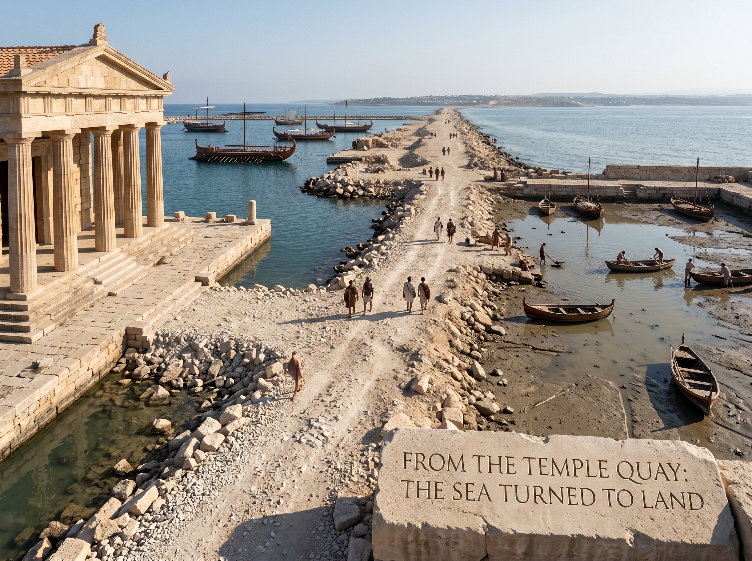
From the temple quay: the sea turned to land
The mole rewired civic rituals by replacing a water threshold with a pale band of hauled stone that people now had to cross. Where the temple quay once faced a blue channel, priests and sailors found a raw causeway blocking the view; processions that had begun with a boat now began on dust and gravel, and the temple’s sightlines to anchored fleets were interrupted by overturned skiffs and silt-choked slipways. Dye workshops that had relied on quick boat access saw their vats effectively moved inland as mooring shifted to deeper basins; warehouses crept toward the new quays and some royal storage yards were re-sited to follow the new traffic. The civic choreography — who boarded where, how sacred oaths were taken before departure, where tolls were collected — all had to be remapped onto a changing shoreline.
The causeway altered processional routes and forced relocation of some maritime industries when former quays became unusable.
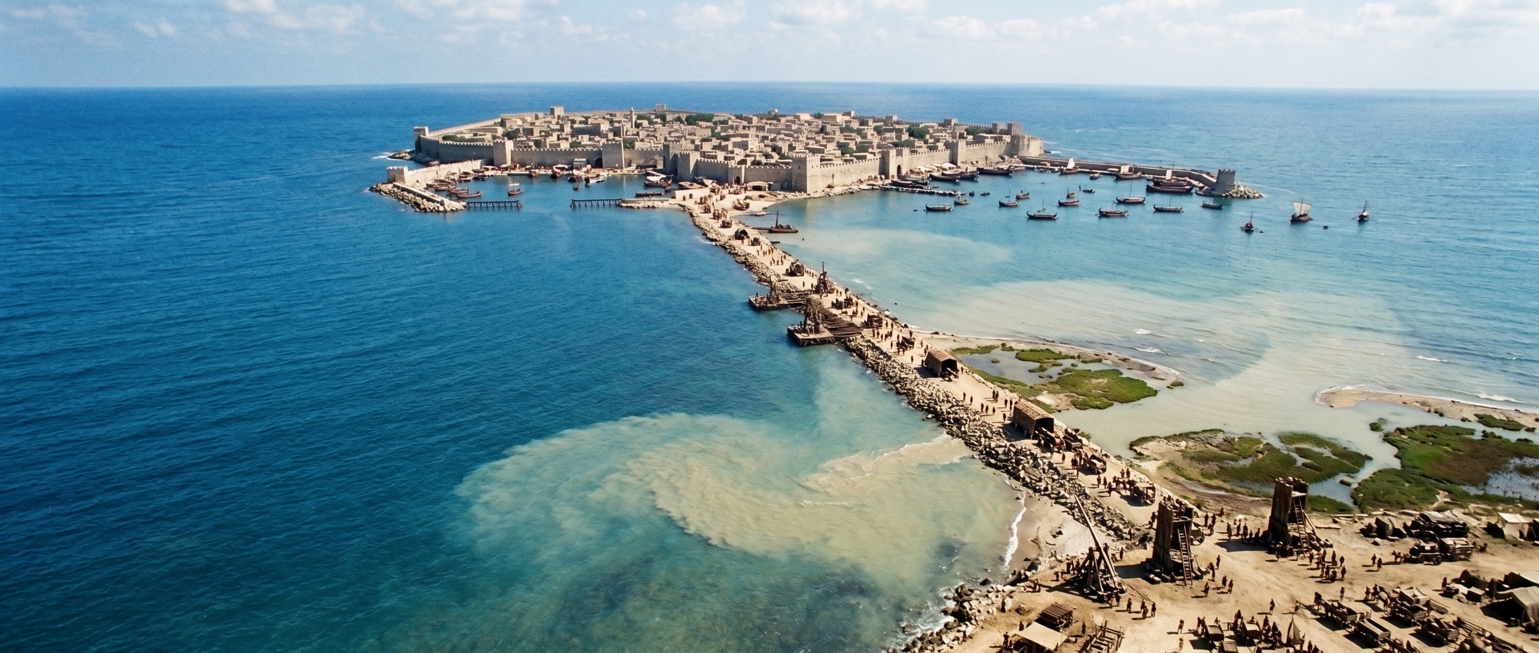
Aerial panorama: island, mole, and the reconfigured harbour
Seen in plan, the mole read as a long, linear interruption whose geometry determined where water could move and where silt would settle. The causeway ran roughly a kilometre from mainland to island, slicing the harbor’s circulation so that outer basins kept depth while inner basins fell quiet and turned turbid. Eddies formed on the lee side of the spit; their slow churn dropped shell, sand, and battered ballast in predictable crescents, so marsh and reclaimed strips began to appear within a few decades. Ships clustered where deeper water remained, and the pattern of anchorages shifted outward, compressing commercial traffic into narrower stretches of sea and concentrating wear on the surviving quays.
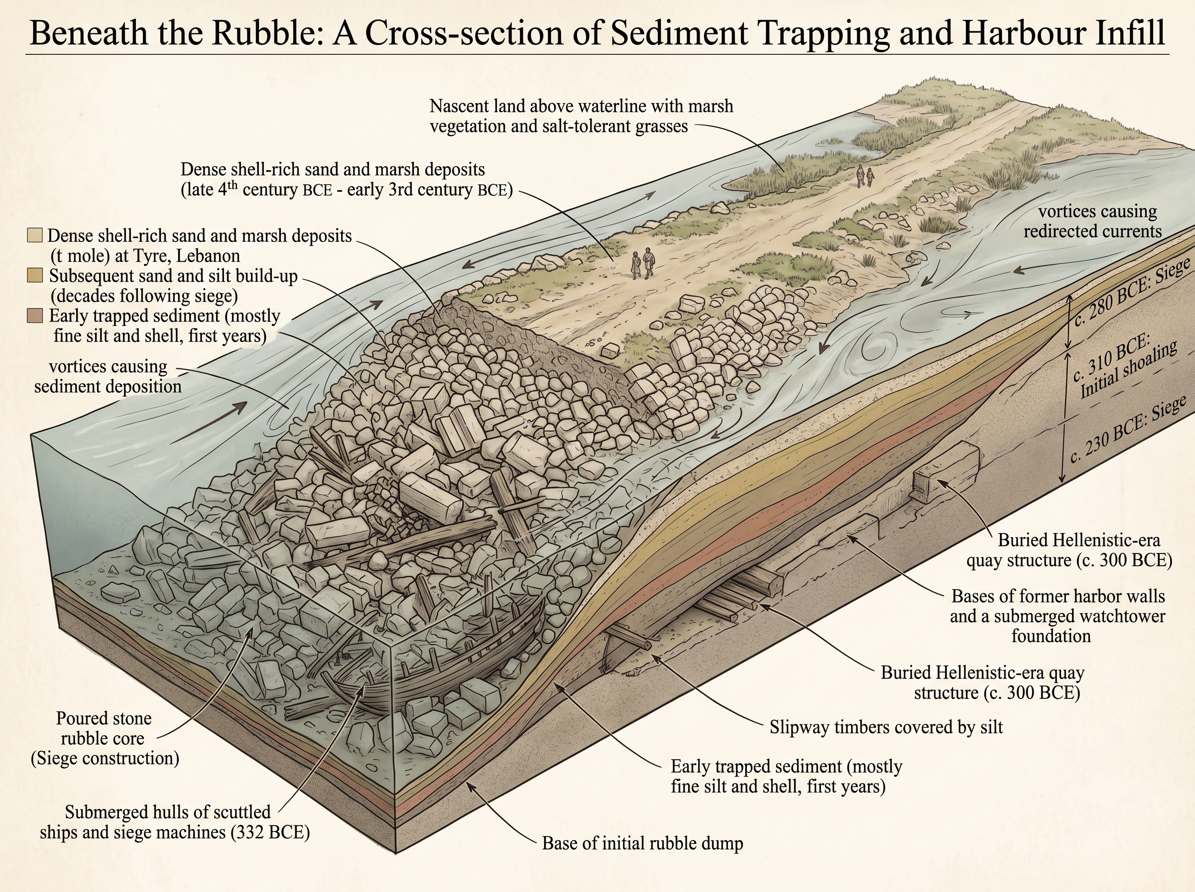
Beneath the rubble: a cross-section of sediment trapping and harbour infill
Beneath the rough surface lay the real story: a piled core of stone and timber that slowed currents and let sediment do the rest. The buried sequence ran from crushed hulls and hauled rock at the base to layered deposits of shell-rich sand and fine silt above, interleaved with the timbers of former slipways and quay foundations. Those shell-rich layers came partly from local murex middens and broken cargo; once flow dropped behind the mole, the heavy shell fragments fell out first and accelerated infill. Over decades those layers built a new substrate that buried quay bases and changed ground-bearing capacity — the island’s walls kept their silhouette, but their maritime footing had been remade from below.
Shell middens near the quays contributed significant coarse material that accumulated quickly once currents slowed behind the causeway.
City context
The mole sat at the threshold between Tyre’s island heart and the mainland that carried timber, stone, and the hinterland supplies that fed the port economy. Before the causeway, captains tied up along quays that ran the island’s edges; crews walked narrow spine streets to the palace and temple. The channel that separated island and mainland was part of daily choreography: small boats for short errands, larger ships anchored in the outer harbor. The causeway reconfigured those movements into land routes.
For ordinary Tyrians the change arrived twice: first as a spectacle and a crisis during the siege — the sight of a man-made road pushing into the sea, the smell of crushed hulls, the anxiety of a clear sea lane being closed — and then as a slow, practical reality as new quays and streets extended across reclaimed ground. Dye-workers, shipwrights, and priests found their spatial relations altered: some slipways choked with silt, some warehouses moved to new quays, and processional routes to the temple no longer faced the open channel. The causeway thereby shifted who controlled access to trade and how the city measured its authority over maritime exchange.
Sources
classical text
- Diodorus Siculus, Bibliotheca historica, Book 17 (account of Alexander’s siege of Tyre)
- Arrian, Anabasis Alexandri (narrative of Alexander’s campaigns)
- Quintus Curtius Rufus, Historiae Alexandri Magni (descriptions of the mole and siege works)
modern synthesis
- Glenn Markoe, Phoenicians (comprehensive modern synthesis on Tyre and Phoenician maritime economy)
secondary literature
- Studies in coastal geomorphology and historical harbours (scholarly articles on sedimentation and harbour infill relevant to Tyre’s causeway)